| Identification / पहचान | |
| Reference Number / संदर्भ संख्या | DL01011543 |
| Built Heritage/Site निर्मित धरोहर / स्थल |
Built Heritage |
| Name of the Monument / Built Heritage / Site स्मारक / निर्मित धरोहर / स्थल का नाम |
Well |
| State / राज्य | Delhi |
| District / जिला | North West |
| Manual District | |
| Sub District / उप-जिला | Others |
| Manual Sub District | Vasant Vihar |
| Village / गाँव | Others |
| Manual Village | Humayunpur |
| Cultural Affiliation / सांस्कृतिक सम्बंधन | Late Medieval - उत्तर मध्यकाल |
| Date/Period तारीख/युग |
C. 19th - 20th Cent. CE |
| Sub Period | Late Mughul |
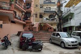
| Geo-Location / भू-अवस्थिति | South end of Humayunpur Village, Safdarjung Enclave on the road going southwards, from block B.4 |
| Latitude / अक्षांश | 28 33 36 |
| Longitude / देशान्तर | 77 10 39 |
| Approach to the Monument / पहुंचने का मार्ग | |
| Approach /पहुंचने का मार्ग | Approx. 300 m to the south-east of Tin Burji tomb and 450 m to the south-west of Bhikaji Kama Place metro station via Africa Avenue Marg and Vivekanand Marg |
| Air Port / विमानपत्तन | IGI |
| Railway Station / रेलवे स्टेशन | Nizamuddin |
| Bus Station / बस स्टैंड | Safdarjung |
| Topographical Features / स्थलाकृतिक विशेषताएं | |
| Topographical Feature / स्थलाकृतिक विशेषताएं | Others- अन्य |
| Topographical Description / स्थलाकृतिक विवरण | It lies in area between the flood plain of river Yamuna and Delhi Ridge on the West. Delhi ridge is a northern extension of ancient Aravalli Range. |
| History / इतिहास | |
| Brief History / संक्षिप्त इतिहास | This is the historic well of the village. The need to tap ground water, store rain water and to make it accessible to the human population living surrounding has led to the construction of several well, which also became an epitome of the art and architecture of the local people. |
| Local / Traditional description associated with Built Heritage / Site निर्मित धरोहर / स्थल से सम्बंधित स्थानीय/ परम्परागत विवरण |
The well exists in the center of the village has high cultural relevance until this day for the village community. Some rituals have been performed during marriage and other traditional occasions. |
| Architectural Style / स्थापत्य शैली | Vernacular- क्षत्रीय |
| Building/ Structure/Site
इमारत / संरचना / स्थल |
|
| Description of Building/ Structure/Site
इमारत/संरचना/स्थल का विवरण |
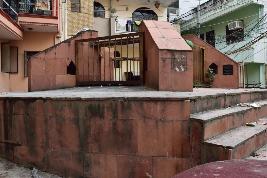
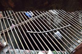
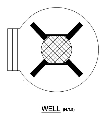
The well is circular in plan and is very deep. Its diameter is approx. 3.65 m and sandstone slabs are fixed over the mouth on each of its four sides. It can be approached through a flight of seven steps. It is covered with iron grill, on and around the mouth. The land surface around the well mounded so that surface water runs away from the well and is not allowed to pond around the outside of the well head. The well is lined with stones and mortar to prevent collapse. |
| Structure material and other material संरचनागत सामग्री और अन्य घटक |
|
| Building/Structure material and other material used प्रयोग में लाई गई इमारती / संरचनागत सामग्री और अन्य घटक |
The structure is constructed of random rubble masonry and faced with red sandstone tiles. |
| Usage(s) & Sub Type | |
| Usage(s) / प्रयोग | Non-Living Monument - प्रयोग मे नहीं |
| Sub-Usage(s)/ उप-प्रयोग | N.A |
| Ownership / स्वामित्व | Public - जनता |
| Protection status / संरक्षण अवस्था | Unprotected- असंरक्षित |
| Plan/Elevation विन्यास/उध्र्व विन्यास |
|
| Published Reference / प्रकाशित संदर्भ | |
| Author / लेखक | INTACH, Delhi Chapter |
| Name / नाम | Delhi The Built Heritage - A Listing INTACH |
| Year / वर्ष | 1999 |
| Published/Unpublished प्रकाशित / अप्रकाशित |
Published |
| © Disclaimer:NMMA may be contacted for any further information. The documented data is under correction and subject to validation. |