| Identification / पहचान | |
| Reference Number / संदर्भ संख्या | TN01001448 |
| Built Heritage/Site निर्मित धरोहर / स्थल |
Built Heritage |
| Name of the Monument / Built Heritage / Site स्मारक / निर्मित धरोहर / स्थल का नाम |
Pallavada |
| State / राज्य | Tamil Nadu |
| District / जिला | Thiruvallur |
| Manual District | |
| Sub District / उप-जिला | Gummidipoondi (TP) |
| Manual Sub District | |
| Village / गाँव | |
| Manual Village | |
| Cultural Affiliation / सांस्कृतिक सम्बंधन | Early Medieval - प्रारम्भिक मध्यकाल |
| Date/Period तारीख/युग |
C. 9th - 10th Cent. CE |
| Sub Period | |
| Geo-Location / भू-अवस्थिति | The locality studied lay east of the road en route to Kannambakkam. |
| Latitude / अक्षांश | 13 28 44 |
| Longitude / देशान्तर | 80 13 1 |
| Approach to the Monument / पहुंचने का मार्ग | |
| Approach /पहुंचने का मार्ग | N.A |
| Air Port / विमानपत्तन | Chennai |
| Railway Station / रेलवे स्टेशन | Gummidipoondi |
| Bus Station / बस स्टैंड | Pallavada |
| Topographical Features / स्थलाकृतिक विशेषताएं | |
| Topographical Feature / स्थलाकृतिक विशेषताएं | Plain- मैदान |
| Topographical Description / स्थलाकृतिक विवरण | The site is located in the context of a shallow weathered shallow buried pediplain, in the context of lateritic formations. |
| History / इतिहास | |
| Brief History / संक्षिप्त इतिहास | This site was explored by Pappu et al. 2010a,b,c 2011 |
| Local / Traditional description associated with Built Heritage / Site निर्मित धरोहर / स्थल से सम्बंधित स्थानीय/ परम्परागत विवरण |
Not Applicable |
| Architectural Style / स्थापत्य शैली | N.A - उपलब्ध नहीं |
| Building/ Structure/Site
इमारत / संरचना / स्थल |
|
| Description of Building/ Structure/Site
इमारत/संरचना/स्थल का विवरण |
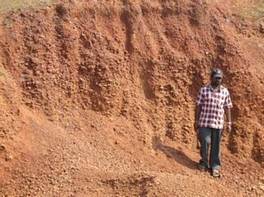
The artefact horizon comprises an indurated ferricrete gravel around 20-30 cm thick, with artefacts often embedded within the duricrust. This overlies a Cenozoic laterite profile Unit 3 , base of which cannot be seen. The site is extensively quarried and disturbed, owing to both quarrying and road construction which dissects the area. A very low density of tools is seen across the area, only around 1 to 2 artefacts m2 although the density increases as one moves west across the site. |
| Structure material and other material संरचनागत सामग्री और अन्य घटक |
|
| Building/Structure material and other material used प्रयोग में लाई गई इमारती / संरचनागत सामग्री और अन्य घटक |
Not Applicable |
| Usage(s) & Sub Type | |
| Usage(s) / प्रयोग | N.A - उपलब्ध नहीं |
| Sub-Usage(s)/ उप-प्रयोग | |
| Ownership / स्वामित्व | N.A - उपलब्ध नहीं |
| Protection status / संरक्षण अवस्था | Unprotected- असंरक्षित |
| Plan/Elevation विन्यास/उध्र्व विन्यास | |
| Published Reference / प्रकाशित संदर्भ | |
| Author / लेखक | Pappu, S., A. Kumar, S. Ravindranath and Uday Raj |
| Name / नाम | Applications of Satellite Remote Sensing for Research and Heritage Management in Indian Prehistory, Journal of Archaeological Science |
| Year / वर्ष | |
| Published/Unpublished प्रकाशित / अप्रकाशित |
Published |
| © Disclaimer:NMMA may be contacted for any further information. The documented data is under correction and subject to validation. |