| Identification / पहचान | |
| Reference Number / संदर्भ संख्या | TN03001447 |
| Built Heritage/Site निर्मित धरोहर / स्थल |
Built Heritage |
| Name of the Monument / Built Heritage / Site स्मारक / निर्मित धरोहर / स्थल का नाम |
Orathur Orattur |
| State / राज्य | Tamil Nadu |
| District / जिला | Kancheepuram |
| Manual District | |
| Sub District / उप-जिला | Karunguzhi (TP) |
| Manual Sub District | |
| Village / गाँव | |
| Manual Village | |
| Cultural Affiliation / सांस्कृतिक सम्बंधन | Prehistoric - प्रागैतिहासिक काल |
| Date/Period तारीख/युग |
C. 9th - 10th Cent. CE |
| Sub Period | |
| Geo-Location / भू-अवस्थिति | The site is located between Orattur to Kilianur, and in the vicinity of the Kiliyar stream. |
| Latitude / अक्षांश | 12 29 26 |
| Longitude / देशान्तर | 79 47 36 |
| Approach to the Monument / पहुंचने का मार्ग | |
| Approach /पहुंचने का मार्ग | N.A |
| Air Port / विमानपत्तन | Chennai |
| Railway Station / रेलवे स्टेशन | Madhuranthangam |
| Bus Station / बस स्टैंड | Madhuranthangam |
| Topographical Features / स्थलाकृतिक विशेषताएं | |
| Topographical Feature / स्थलाकृतिक विशेषताएं | Plain- मैदान |
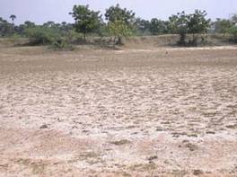
| Topographical Description / स्थलाकृतिक विवरण | The site is located on a weathered buried pediplain. |
| History / इतिहास | |
| Brief History / संक्षिप्त इतिहास | Foote 1916a,b noted tools amongst kunkary lateritic gravel. Swami 1976 reports the context as being on the high ground to the northwest of the village, around 20 above the surrounding area in a conglomerate with kankar. Based on their information the coordinates are 12 28 41.318 N and 79 47 58.605 E |
| Local / Traditional description associated with Built Heritage / Site निर्मित धरोहर / स्थल से सम्बंधित स्थानीय/ परम्परागत विवरण |
Not Applicable |
| Architectural Style / स्थापत्य शैली | N.A - उपलब्ध नहीं |
| Building/ Structure/Site
इमारत / संरचना / स्थल |
|
| Description of Building/ Structure/Site
इमारत/संरचना/स्थल का विवरण |
The white sandy gravels were noted over an area of over 1 sq.km. The stratigraphic sequence comprises white sandy gravels with kankar which overlies the Talchir formation, and occurs more in the nature of a lag deposit. The area surveyed was around 200 m2. Artefact density is around around 1-2 artefacts 5 m2 and thus very low. The presence of two artefacts on quartzite of which one is a very rolled chopping tool and one a fresh core fragment, possibly leading to interpretations of previous scholars that this constitutes an Early Stone Age site. |
| Structure material and other material संरचनागत सामग्री और अन्य घटक |
|
| Building/Structure material and other material used प्रयोग में लाई गई इमारती / संरचनागत सामग्री और अन्य घटक |
Not Applicable |
| Usage(s) & Sub Type | |
| Usage(s) / प्रयोग | N.A - उपलब्ध नहीं |
| Sub-Usage(s)/ उप-प्रयोग | Waste land |
| Ownership / स्वामित्व | N.A - उपलब्ध नहीं |
| Protection status / संरक्षण अवस्था | Unprotected- असंरक्षित |
| Plan/Elevation विन्यास/उध्र्व विन्यास | |
| Published Reference / प्रकाशित संदर्भ | |
| Author / लेखक | Foote, R.B. |
| Name / नाम | The Foote Collection of Indian Prehistoric and Protohistoric Antiquities. Catalouge Raisonne. Chennai The Commissioner of Museums. Government Museum, Chennai. |
| Year / वर्ष | |
| Published/Unpublished प्रकाशित / अप्रकाशित |
Published |
| © Disclaimer:NMMA may be contacted for any further information. The documented data is under correction and subject to validation. |