| Identification / पहचान | |
| Reference Number / संदर्भ संख्या | TN01001376 |
| Built Heritage/Site निर्मित धरोहर / स्थल |
Built Heritage |
| Name of the Monument / Built Heritage / Site स्मारक / निर्मित धरोहर / स्थल का नाम |
Aryathur Ariyathur Ariyapakkam |
| State / राज्य | Tamil Nadu |
| District / जिला | Thiruvallur |
| Manual District | |
| Sub District / उप-जिला | Thiruvallur (M) |
| Manual Sub District | |
| Village / गाँव | |
| Manual Village | |
| Cultural Affiliation / सांस्कृतिक सम्बंधन | Prehistoric - प्रागैतिहासिक काल |
| Date/Period तारीख/युग |
C. 9th - 10th Cent. CE |
| Sub Period | |
| Geo-Location / भू-अवस्थिति | The site is located in the vicinity of a tank, in the upper reaches of a stream draining east towards Attirampakkam. A temple is situated in the vicinity. |
| Latitude / अक्षांश | 13 14 49 |
| Longitude / देशान्तर | 79 51 54 |
| Approach to the Monument / पहुंचने का मार्ग | |
| Approach /पहुंचने का मार्ग | Not Applicable |
| Air Port / विमानपत्तन | Chennai |
| Railway Station / रेलवे स्टेशन | Thiruvallur |
| Bus Station / बस स्टैंड | Nambakkam |
| Topographical Features / स्थलाकृतिक विशेषताएं | |
| Topographical Feature / स्थलाकृतिक विशेषताएं | Plain- मैदान |
| Topographical Description / स्थलाकृतिक विवरण | The site is located around 2 km upstream of Attrambakkam, near the tank from where the Attrambakkam gully originates. The area is dissected by a north-south flowing gully and numerous rain rills. The region comprises weathered pediplain. |
| History / इतिहास | |
| Brief History / संक्षिप्त इतिहास | This was surveyed by Pappu 1996, 2001a,b Pappu et al. 2010a,b,c 2011 |
| Local / Traditional description associated with Built Heritage / Site निर्मित धरोहर / स्थल से सम्बंधित स्थानीय/ परम्परागत विवरण |
Not Applicable |
| Architectural Style / स्थापत्य शैली | N.A - उपलब्ध नहीं |
| Building/ Structure/Site
इमारत / संरचना / स्थल |
|
| Description of Building/ Structure/Site
इमारत/संरचना/स्थल का विवरण |
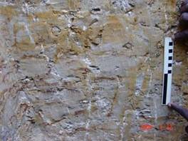
Late Acheulian and Middle Palaeolithic artefacts erode out of a 10-20 cm thick ferricrete gravel which in turn rests on the surface of Sriperumbudur Avadi Cretaceous shales. The ferricretes have been considerably eroded and are capped by a clayey-silts with calcrete nodules, the thickness of which varies from 10 cm to around 1 m as one moves down the gully. The site covers an area of around 4 sq km, and occassional artefact spreads are noted in surrounding areas where ferricrete gravels are exposed. Artefacts are largely unabraded and occasional patined white owing to presence of calcrete nodules, they are largely on quartzites or quartzitic sandstones. Description of artefact types is provided by Pappu 1996,2001a,b . |
| Structure material and other material संरचनागत सामग्री और अन्य घटक |
|
| Building/Structure material and other material used प्रयोग में लाई गई इमारती / संरचनागत सामग्री और अन्य घटक |
Not Applicable |
| Usage(s) & Sub Type | |
| Usage(s) / प्रयोग | N.A - उपलब्ध नहीं |
| Sub-Usage(s)/ उप-प्रयोग | Waste land |
| Ownership / स्वामित्व | N.A - उपलब्ध नहीं |
| Protection status / संरक्षण अवस्था | Unprotected- असंरक्षित |
| Plan/Elevation विन्यास/उध्र्व विन्यास | |
| Published Reference / प्रकाशित संदर्भ | |
| Author / लेखक | Pappu, S., A. Kumar, S. Ravindranath and Uday Raj |
| Name / नाम | Applications of Satellite Remote Sensing for Research and Heritage Management in Indian Prehistory, Journal of Archaeological Science . |
| Year / वर्ष | |
| Published/Unpublished प्रकाशित / अप्रकाशित |
Published |
| © Disclaimer:NMMA may be contacted for any further information. The documented data is under correction and subject to validation. |